Training & Consulting
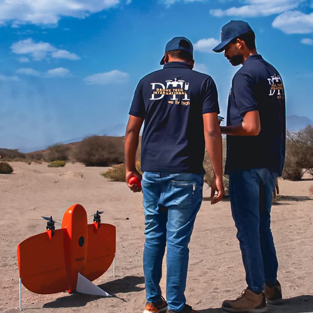
Drone Training & Consulting
Our Drone Training & Consulting service empowers individuals and organizations with the skills and strategic insights needed to excel in the rapidly evolving drone industry. We specialize in pilot certification courses and tailored corporate drone training programs, ensuring that participants gain both the theoretical foundation and hands-on experience required for safe and effective drone operations.
Service Description
Our comprehensive training programs cover all facets of drone operation, from basic flight mechanics to advanced piloting techniques and regulatory compliance. Whether you are an aspiring pilot seeking certification or a corporation looking to integrate drone technology into your operations, our services are designed to meet your unique needs:
- Pilot Certification: Gain in-depth knowledge and practical experience to meet certification requirements. Our courses cover flight safety, airspace regulations, advanced piloting skills, and exam preparation.
- Corporate Drone Training Programs: Customized training solutions that focus on integrating drone technology into business operations. Topics include operational planning, risk management, compliance, and real-time application tailored to your industry.
- Consulting Services: Strategic consulting to help businesses develop and implement effective drone programs, optimize operational workflows, and stay current with evolving regulations and technologies.
How We Conduct Our Services
1. Needs Assessment & Program Design
- Customized Consultation: We start with an in-depth evaluation of your training or corporate needs, identifying skill gaps and defining key objectives.
- Tailored Curriculum Development: Our expert team crafts a customized curriculum combining theoretical modules with practical flight training, ensuring all critical topics—from safety protocols to advanced operational techniques—are thoroughly addressed.
2. Training Delivery
- Classroom Instruction: Comprehensive theoretical sessions cover drone technology fundamentals, aviation regulations, and industry best practices.
- Hands-On Flight Training: Practical sessions provide real-world piloting experience using state-of-the-art training drones and simulators, guided by certified instructors.
- Interactive Workshops & Scenario-Based Drills: Engaging workshops and simulated emergency scenarios build decision-making skills and operational confidence.
3. Consulting & Continuous Support
- Operational Strategy Consulting: We work with corporate clients to develop effective strategies for integrating drone operations into their business, ensuring compliance and operational efficiency.
- Ongoing Mentorship & Updates: Our support extends beyond the training period, offering continuous guidance on regulatory updates, emerging technologies, and advanced training opportunities.
4. Assessment & Certification
- Performance Evaluation: Rigorous assessments evaluate both theoretical knowledge and practical skills, ensuring readiness for official certification.
- Certification Preparation: Dedicated exam preparation sessions, including practice tests and personalized feedback, equip participants to succeed in their certification exams.
Outputs & Deliverables
Our Drone Training & Consulting service is dedicated to building the foundation for safe, proficient, and strategic drone operations. Whether you are pursuing individual pilot certification or implementing a corporate drone program, our expert-led training and consulting services provide the essential tools and knowledge to elevate your capabilities. Contact us today to learn how we can help you navigate the skies with confidence.
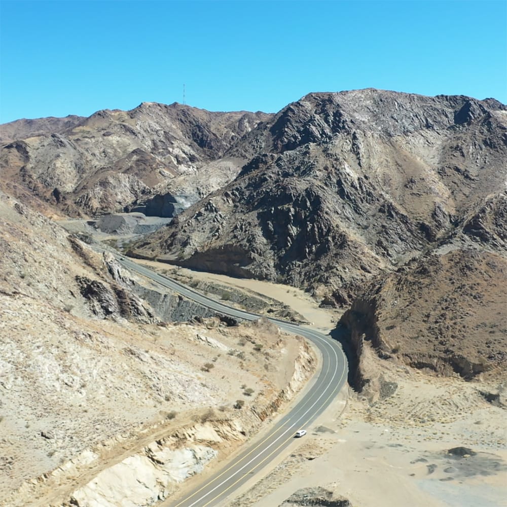
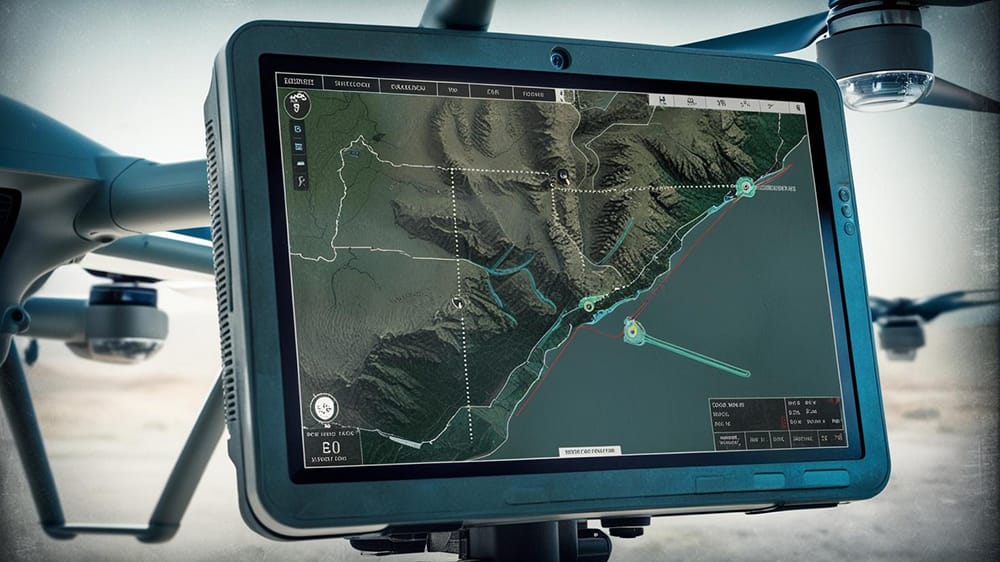
Aerial Mapping & Surveying
Our Aerial Mapping & Surveying service leverages cutting-edge drone technology to capture, process, and deliver high-resolution geospatial data with unmatched precision and efficiency. This service is designed to support various industries—from construction and engineering to agriculture and environmental management—by providing accurate, up-to-date mapping information that informs decision-making and drives project success.
Service Description
Our service employs state-of-the-art drones equipped with high-resolution cameras, LiDAR sensors, and advanced GPS systems. These drones are capable of capturing comprehensive aerial imagery and sensor data across expansive areas, even in hard-to-reach locations. By flying pre-programmed routes, our drones collect overlapping images and detailed measurements necessary for creating accurate geospatial models.
- Advanced Sensor Integration: Our drones are fitted with precision instruments such as high-definition cameras and LiDAR sensors. This allows for versatile data collection, from capturing vibrant, detailed aerial photographs to measuring precise elevation and surface characteristics.
- High Accuracy & Efficiency: Utilizing technologies like Real-Time Kinematic (RTK) GPS ensures that every data point is accurately georeferenced, providing reliable outputs essential for detailed mapping and analysis.
How We Conduct Our Services
1. Pre-Flight Planning & Permissions
- Project Scoping: We start by understanding your project’s specific requirements, survey area, and objectives.
- Risk Assessment & Compliance: Comprehensive risk assessments and the necessary regulatory permissions are obtained to ensure a safe and legal operation.
- Flight Path Design: Detailed flight plans are created, incorporating optimal flight altitudes, sensor settings, and overlapping routes to ensure complete coverage of the survey area.
2. Data Acquisition
- Drone Deployment: Our trained pilots deploy drones on scheduled flights, capturing high-resolution imagery and sensor data across the designated area.
- Precision Data Collection: Using advanced GPS and RTK systems, each data point is accurately recorded, ensuring that the subsequent processing yields precise, georeferenced outputs.
3. Data Processing & Analysis
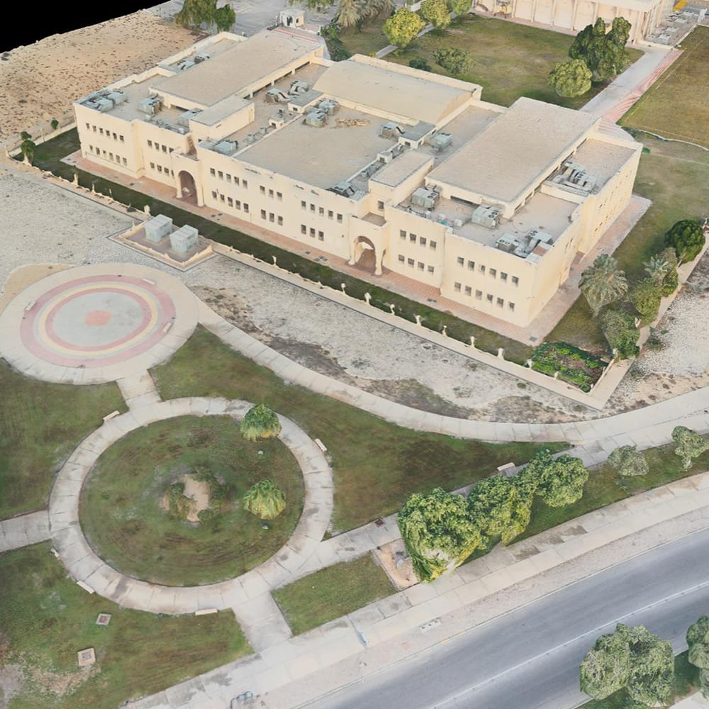
- Photogrammetry & 3D Modeling: Collected images are processed using advanced photogrammetry software to stitch together seamless orthomosaic maps and generate detailed 3D point clouds.
- Quality Control: Rigorous quality checks and data validation ensure that the final outputs meet high standards of accuracy and detail.
- Integration with GIS: The processed data is formatted into GIS-compatible layers, making it easy to integrate with your existing systems and workflows.
4. Reporting & Delivery
- Custom Reports: We generate detailed reports that include annotated maps, elevation models, and volumetric analyses, tailored to your project’s needs.
- Interactive Deliverables: Optional interactive web maps and digital platforms can be provided, allowing you and your stakeholders to explore the data dynamically.
- Timely Delivery: Our streamlined process ensures that you receive actionable, high-quality deliverables within agreed timeframes.
Outputs & Deliverables
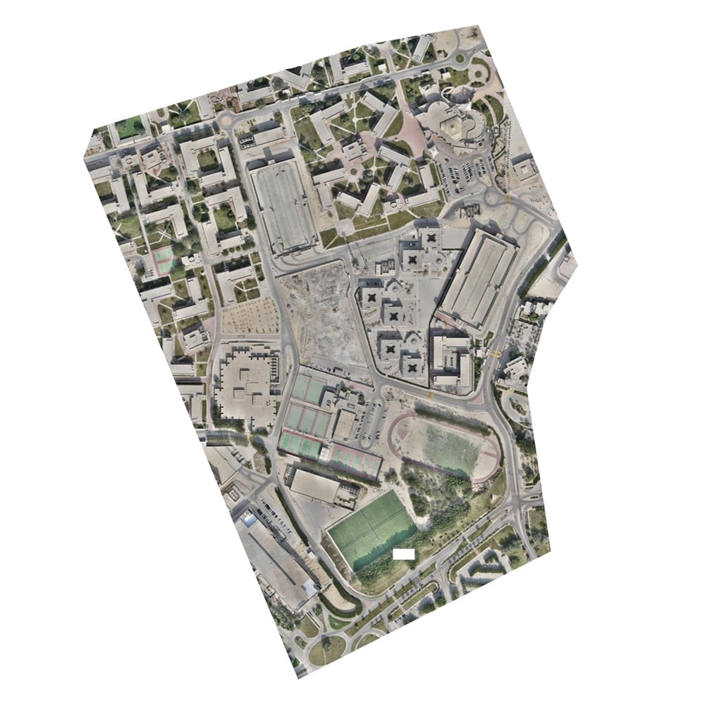
Orthomosaic Maps: High-resolution, georeferenced aerial maps that provide a comprehensive visual representation of the surveyed area.

3D Models & Point Clouds: Realistic 3D representations of your site (including terrain, buildings, and structures) for visualization, design, and digital twin initiatives.
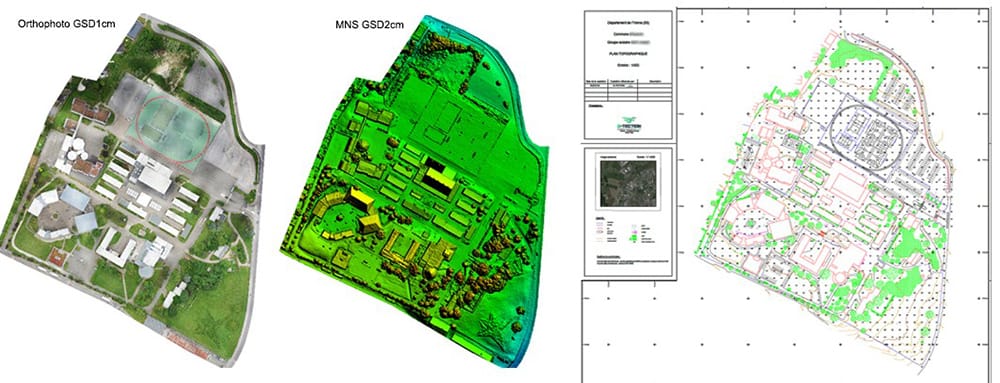
2D CAD Master Plans: Providing detailed, georeferenced site layouts include terrain features, contours, structures, and utilities—delivered in CAD-ready formats (DWG/DXF) for seamless integration into engineering, planning, and construction workflows.
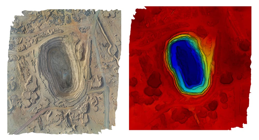
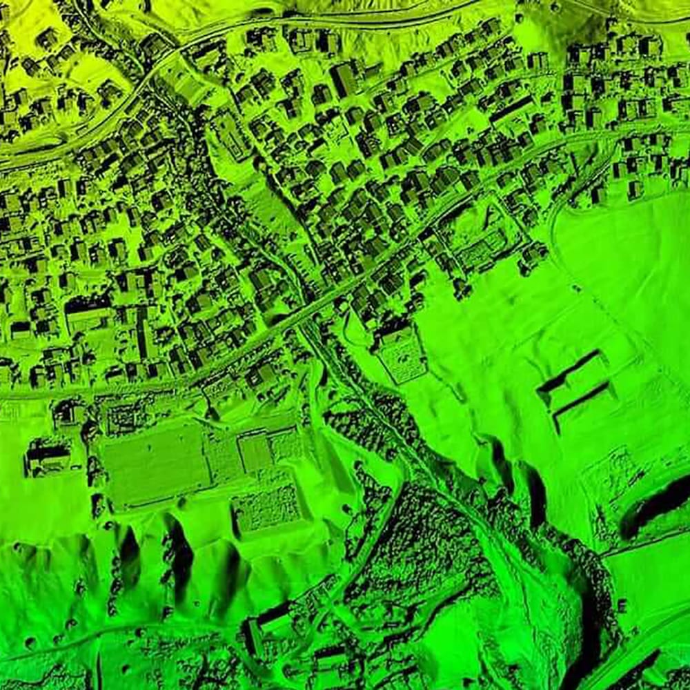
Digital Elevation Models (DEM) & Digital Surface Models (DSM): Elevation and surface models that detail topographical variations and surface features, essential for planning and analysis.
GIS Data Layers: Ready-to-use datasets that can be seamlessly integrated into your GIS software for ongoing spatial analysis and project planning.
 Customized Reports: In-depth analysis and visual presentations that highlight key findings, such as topographic variations, volumetric calculations, and critical infrastructure details.
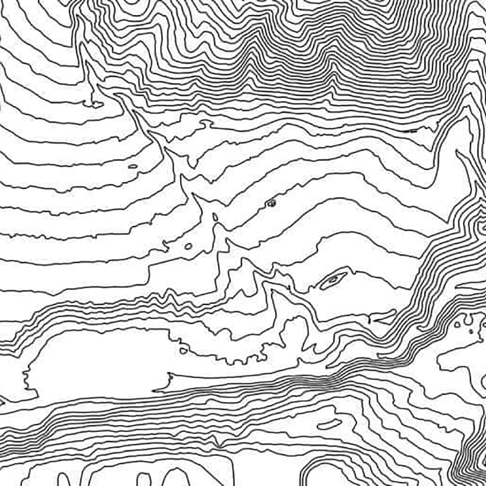
Contour Map: Contour lines, generated from an accurate Digital Terrain Model (DTM), clearly represent topographic features such as slopes, hills, and depressions by connecting points of equal elevation. When overlaid with orthophotos or DSM/DTM data, they provide a powerful visual representation of the terrain, making it easier to interpret landscape features.
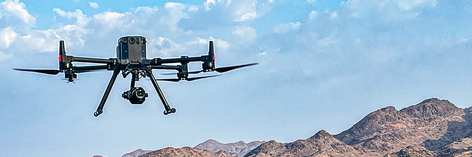
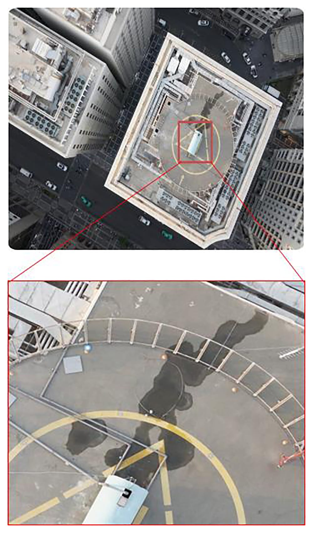
Inspection & Monitoring
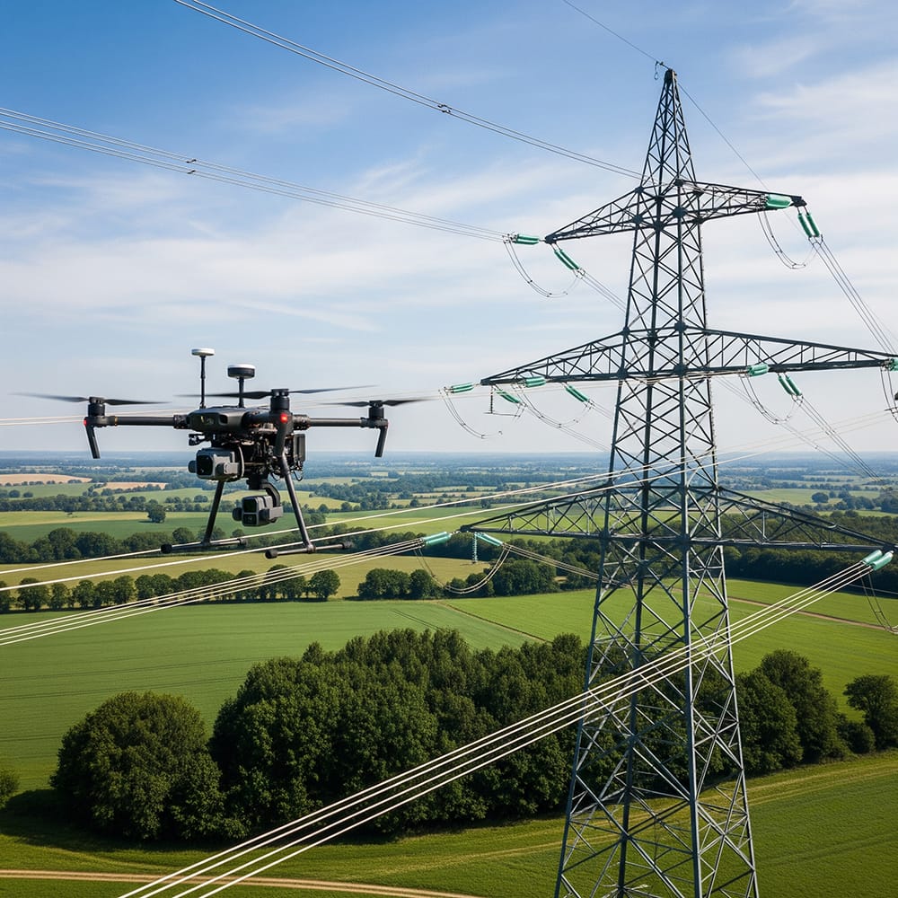
Our Drone Inspection & Monitoring service offers a state-of-the-art solution for the routine and critical evaluation of infrastructure. Leveraging advanced drone technology, this service is specifically tailored for inspecting power lines, oil & gas facilities, and construction sites. It provides a safe, efficient, and cost-effective alternative to traditional manual inspections, ensuring that potential issues are identified early and maintenance decisions are well-informed.
Service Description
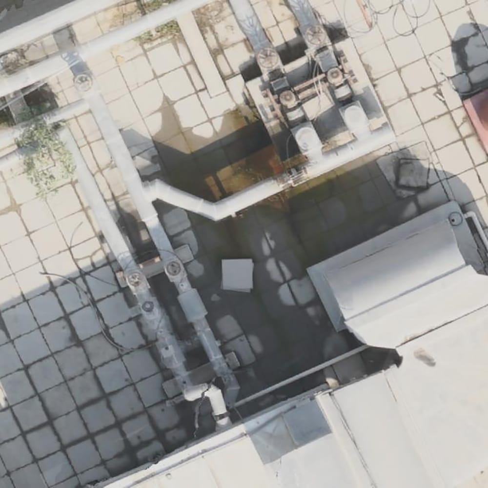
Our service utilizes drones equipped with high-definition cameras, thermal imaging, LiDAR sensors, and other advanced instruments. This enables us to capture detailed imagery and sensor data from various infrastructure assets. Whether assessing the integrity of power lines, monitoring the condition of oil & gas facilities, or tracking the progress and safety compliance of construction sites, our system is designed to deliver precision and actionable insights.
- Infrastructure Inspection Focus:
- Power Lines: Detecting signs of corrosion, vegetation encroachment, and structural wear that may pose safety risks or cause power outages.
- Oil & Gas Facilities: Monitoring pipelines, storage tanks, and processing units for leaks, corrosion, and other structural anomalies.
- Construction Sites: Conducting regular progress assessments, safety checks, and quality control inspections to ensure project milestones and standards are met.
- Telecommunications Towers: High-resolution visual, thermal, and LiDAR inspections to detect structural issues or equipment malfunctions early.
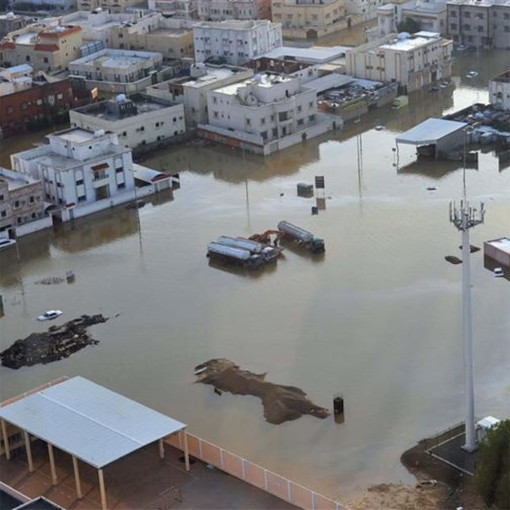
- Insurance Assessments: After events like storms or fires, drones can quickly assess property damage for insurance claims, speeding up the evaluation process.
Advanced Sensor Technology
Our drones integrate multiple sensor modalities—optical, thermal, and LiDAR—providing a comprehensive view of both visible and hidden issues. This multi-layered data collection is critical for thorough inspections, enabling both qualitative and quantitative assessments.
How We Conduct Our Services
1. Pre-Flight Planning & Compliance
- Risk Assessment & Permitting: We begin with a detailed risk assessment and secure all necessary regulatory permits to ensure that every operation is safe and compliant.
- Customized Flight Planning: Our team designs precise flight paths tailored to the specific infrastructure and inspection requirements.
2. Data Acquisition
- Precision Flight Operations: Certified pilots use a combination of automated and manual controls for consistent data capture.
- Real-Time Monitoring: Live feeds to ground control allow immediate adjustments and early detection of issues.
3. Data Processing & Analysis
- High-Resolution Imaging: Imagery and videos are processed to enhance clarity for detailed inspections.
- Thermal & Multispectral Analysis: Identify heat anomalies and detect potential failures or inefficiencies.
- 3D Modeling & Mapping: Generate precise 3D models and maps for a spatial overview of the assets.
4. Reporting & Delivery
- Inspection Reports: Detailed reports with annotated visuals, thermal overlays, and 3D visualizations.
- GIS Integration: GIS-ready layers for integration into asset management systems.
- Interactive Deliverables: Digital dashboards and interactive maps for easy stakeholder collaboration.
Outputs & Deliverables
High-Resolution Visuals: Detailed images and videos of inspected assets.

Thermal Imaging Data: Highlights of heat anomalies and temperature variations.
3D Models & Maps: Georeferenced reconstructions for spatial planning and analysis.
Inspection Reports: Annotated reports with actionable recommendations.
Real-Time Monitoring (Optional): Live data feeds and alert systems for ongoing inspection needs.
Our Drone Inspection & Monitoring service combines precision technology with expert analysis to provide reliable, efficient, and safe infrastructure inspections. By focusing on power lines, oil & gas facilities, and construction sites, we ensure that our clients receive detailed insights and high-quality data necessary for effective maintenance and operational decision-making.
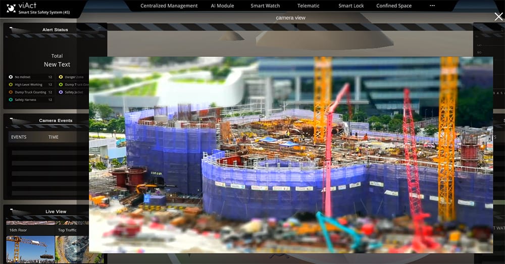
Drone Security & Surveillance
Our Drone Security & Surveillance service is designed to enhance safety and operational efficiency by providing real-time aerial monitoring for security and emergency response. With advanced drone technology, we deliver rapid situational awareness across a range of environments—from large public events to critical infrastructure sites—ensuring that potential threats and emergencies are promptly identified and addressed.
Service Description
This service leverages drones equipped with high-definition cameras, thermal imaging, and an integrated suite of sensors to offer continuous, live monitoring. Our drones can operate in diverse conditions—day or night—to capture detailed visuals and sensor data, which are crucial for both proactive security measures and rapid emergency response. Key applications include:
- Live Security Monitoring: Ideal for overseeing crowded public events, critical infrastructure, and high-security areas.
- Emergency Response: Provides immediate aerial views during disaster situations or urgent incidents, supporting search and rescue operations and rapid response coordination.
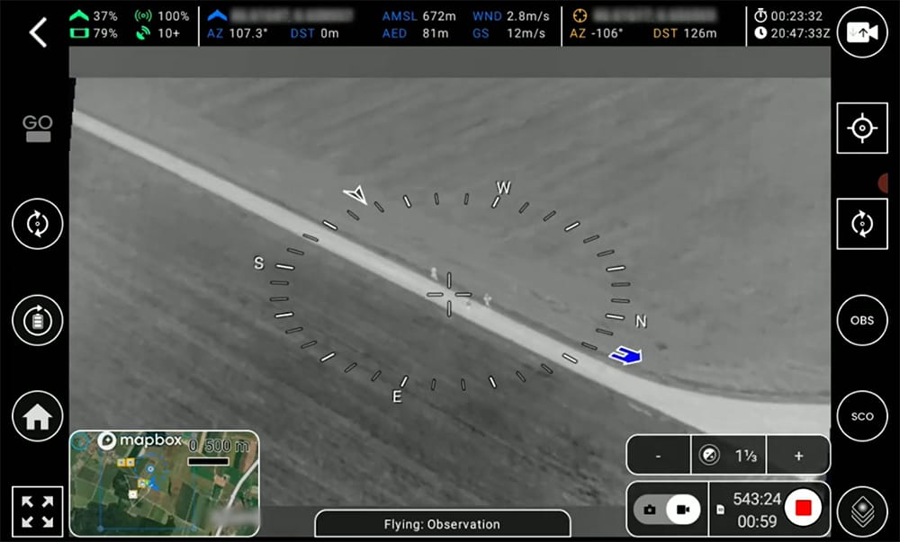
How We Conduct Our Services
1. Pre-Mission Planning & Coordination
- Risk Assessment & Compliance: We perform detailed risk evaluations and secure all necessary regulatory permits to ensure safe and legal operations.
- Customized Flight Path Design: Tailored flight plans are developed to cover specific areas of interest, ensuring comprehensive monitoring of high-risk zones.
- Coordination with On-Ground Teams: We work closely with security personnel and emergency responders to integrate drone data seamlessly into their operational workflows.
2. Live Data Acquisition & Monitoring
- Rapid Deployment: Our drones are quickly deployed to the designated area, ready to capture real-time footage and sensor data.
- Real-Time Video Streaming: High-definition and thermal imaging feeds are transmitted live to command centers, allowing for instant situational analysis.
- Integrated Sensor Suite: Additional sensors, including motion and audio detectors, complement visual data to provide a complete picture of the monitored area.
3. Data Processing & Analysis
- Immediate Alerts & Automated Detection: Advanced algorithms analyze live data to detect unusual activity or potential threats, triggering instant alerts to security teams.
- On-Site Data Verification: Our expert operators monitor the live feed to verify incidents and coordinate with response units as needed.
- Incident Documentation: All critical data and video footage are recorded and archived for post-incident analysis and future reference.
4. Reporting & Integration
- Detailed Incident Reports: Comprehensive reports, including annotated video segments and sensor data logs, are generated to support investigations and ongoing security assessments.
- GIS-Ready Data: Geotagged information is integrated into GIS systems for enhanced spatial analysis and historical record-keeping.
- Interactive Dashboards: Real-time control panels provide security teams with an intuitive interface for monitoring live feeds, reviewing archived data, and coordinating responses.
Outputs & Deliverables
Live Video Streams: Secure, high-definition live feeds, including thermal imaging, accessible in real-time by authorized personnel.
Incident Documentation: Detailed reports featuring annotated video clips, sensor data, and time-stamped event logs for thorough post-incident analysis.

Interactive Monitoring Dashboards: Customizable interfaces that allow security teams to monitor live operations, review historical data, and manage incident responses efficiently.
Our Drone Security & Surveillance service offers an agile, technology-driven solution to enhance public safety and streamline emergency response. By combining rapid deployment, real-time data capture, and advanced analytical tools, we empower security teams to maintain vigilant oversight and respond swiftly to evolving situations. Contact us to learn how our aerial solutions can elevate your security and emergency management strategies.
Aerial Photography & Videography
Our Aerial Photography & Videography service harnesses cutting-edge drone technology to capture breathtaking perspectives that elevate your visual storytelling. Whether showcasing real estate properties, highlighting tourist destinations, covering live events, or creating compelling promotional videos, our service delivers high-quality visuals that engage and inspire your audience.
Service Description
Utilizing state-of-the-art drones equipped with high-resolution cameras, advanced stabilization systems, and intelligent flight controls, we produce stunning imagery and cinematic video footage.
Our service is designed to cater to multiple industries:
- Real Estate: Capture expansive aerial views that highlight property layouts, surrounding landscapes, and architectural details, providing potential buyers with a comprehensive visual overview.
- Tourism: Showcase iconic landmarks, scenic landscapes, and vibrant cultural scenes with immersive aerial footage that entices and informs prospective visitors.
- Events: Document live events with dynamic aerial perspectives, capturing the energy, scale, and unique moments of concerts, festivals, or sports events.
- Promotional Videos: Enhance your brand’s narrative with visually compelling footage that differentiates your marketing content and resonates with your target audience.
How We Conduct Our Services
1. Pre-Production & Planning
- Site Evaluation & Permissions: We begin by assessing the location for optimal shooting angles and ensuring all necessary permits and airspace clearances are secured.
- Concept Development: Collaborate with you to define objectives, develop storyboards, and design a tailored flight path that aligns with your creative vision.
- Technical Setup: Determine the best drone, camera settings, and equipment configuration to capture the desired visual quality and artistic style.
2. Aerial Capture
- Drone Deployment: Our certified drone pilots execute the flight plan, capturing smooth, high-resolution imagery and video from multiple angles and altitudes.
- Real-Time Monitoring: Live feeds allow on-site adjustments to ensure optimal framing, lighting, and composition, capturing every crucial detail.
- Multiple Takes & Angles: We conduct several passes and employ diverse shooting techniques—from sweeping panoramic shots to intricate close-ups—to ensure comprehensive coverage.
Outputs & Deliverables

High-Resolution Photographs: Professionally edited images suitable for digital or print use, capturing the essence of the location or event.

Edited Video Content: Cinematic videos, including full-length features, highlight reels, or promotional clips optimized for various platforms such as websites, social media, or broadcast.
Raw Footage (Optional): For clients who prefer custom post-production, raw drone footage can be provided.

Digital & Print-Ready Formats: Deliverables are supplied in multiple formats to ensure compatibility with all your marketing and distribution channels.
Interactive Media (Optional): Enhance viewer engagement with interactive content such as 360-degree virtual tours or web-based multimedia presentations.
Our Aerial Photography & Videography service is dedicated to transforming your vision into stunning visuals that capture attention and tell your story from a unique vantage point. By combining advanced drone technology with creative expertise, we deliver high-quality, impactful media tailored for real estate, tourism, events, and promotional campaigns.
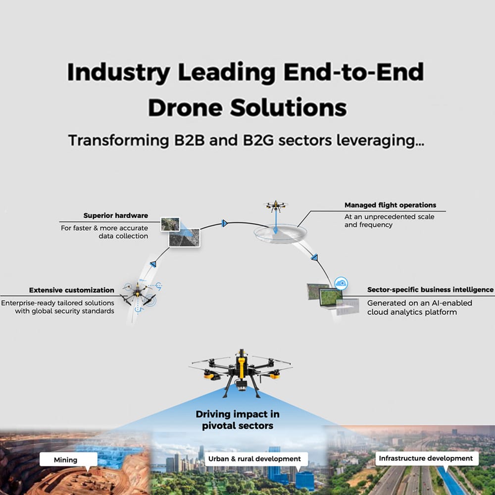
Drone Based Solutions
At Drone Tech International, we provide End-to-End Drone Solutions That Deliver Real Results by combining cutting-edge hardware, intelligent software, and advanced data analytics—tailored to your industry's needs.
What We Deliver:
- High-Performance Drones equipped with industry-specific sensors (LiDAR, thermal, multispectral)
- Smart Software Platforms for data processing, 3D modeling, and real-time reporting
- Actionable Insights powered by AI and cloud-based analysis tools
- Ongoing Support & Training so your team gets the most value, fast
Industries We Serve:
- Construction & Mining: Accurate site surveys, progress tracking, inventory management
- Energy & Utilities: Safe, rapid inspections of power lines, wind farms, and solar fields
- Agriculture: Crop health monitoring, irrigation planning, precision spraying
- Public Safety: Real-time aerial intel for search and rescue, disaster response
Why Choose Our End-to-End Solutions
- Save Time & Reduce Costs
- Increase Safety & Minimize Risk
- Make Smarter, Faster Decisions with Accurate Data
- Scale Easily—From Small Projects to Enterprise Operations
Let us handle the tech—so you can focus on results.
Engineering Services
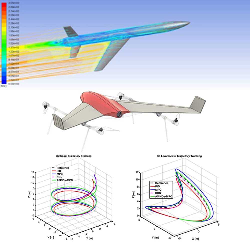
Research and Development (R&D)
- Innovative UAV Development: Drone Tech focuses on creating advanced UAV designs tailored to specific industry needs, ensuring that each system delivers optimal performance and capabilities.
- Technology Integration: By incorporating cutting-edge technologies such as AI, machine learning, and edge computing, we enhance the autonomous capabilities, real-time data processing, and decision-making potential of our drone systems.
- Collaborative Research: Through partnerships with leading academic institutions and research organizations, Drone Tech drives breakthrough innovations in UAV technology.
Prototyping and Testing, Manufacturing and Assembly
- Rapid Prototyping: In-house labs allow for quick design iterations, ensuring continuous improvement in UAV performance.
- Advanced Flight Testing: Real-world and simulated testing to ensure reliability, safety, and adherence to aviation regulatory standards.
- Simulation and Stress Testing: Utilizing cutting-edge simulation platforms to test hardware and software under various operational conditions.
Software Development
- End-to-End Software Solutions: Providing full-spectrum UAV software solutions including flight monitoring, autopilot systems, and secure data management.
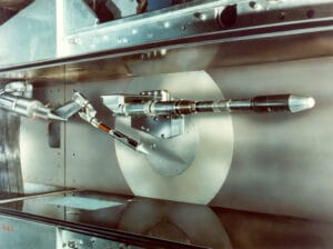
Wind Tunnel Design & Manufacturing
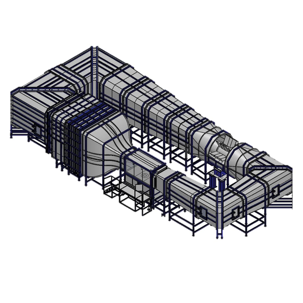
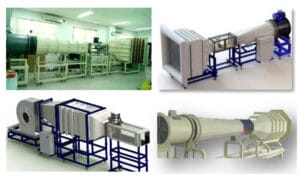
At Drone Tech International (DTI), we offer end-to-end wind tunnel design, engineering, and manufacturing services tailored to the needs of research institutions, universities, and industrial sectors. From conceptual design to fabrication and installation, our team delivers customized wind tunnel systems that meet rigorous aerodynamic testing requirements.
Services We Offer
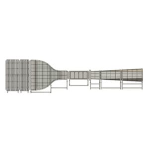
- Custom Wind Tunnel Design
Based on your testing goals (aerodynamic, thermal, environmental), we design open-circuit or closed-circuit wind tunnels, subsonic or supersonic configurations, and modular or fixed installations.
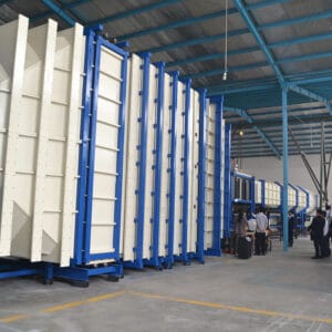
- Manufacturing & Assembly
Precision fabrication using high-grade materials and components for stability, efficiency, and long-term performance.

- Integration & Instrumentation
We install sensors, flow visualization tools, data acquisition systems, and control software tailored to your application.

- Commissioning & Training
Full system setup, calibration, and operator training to ensure optimal performance and usability.
Applications Across Industries
Aerospace & Aviation
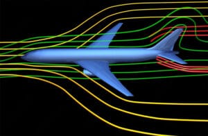
- Aircraft and spacecraft design validation
- Wing and airfoil optimization
- Store separation studies
- High-speed flight dynamics
- Unmanned Aerial Vehicle (UAV) and drone development.
- Turbulence and buffet testing
Automotive & Motorsport

- Aerodynamic drag reduction for fuel efficiency
- Vehicle drag and lift measurements
- Cooling system analysis and design refinement
- Crosswind stability analysis
- Aeroacoustics (wind noise reduction)
- Thermal management of engine bays and brakes
Defense:
- Missile and projectile aerodynamics
- Stealth technology research
- Parachute and re-entry vehicle testing
Architecture & Civil Engineering
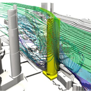
- Wind loading on buildings, bridges, and other structures
- Pedestrian comfort analysis in urban environments
- Dispersion of pollutants from industrial stacks
- Snow drifting and accumulation studies
- Resonance and vortex-induced vibrations in tall structures
Renewable Energy

- Wind turbine blade design and optimization
- Aerodynamic performance of solar panels
- Flow around offshore oil and gas platforms
Education & Research
- Custom-built tunnels for university labs and R&D centers
- Scalable systems for academic teaching and experimentation
Outputs & Deliverables
Fully functional wind tunnel system (modular or permanent)
Engineering drawings and CAD models
Integrated instrumentation and software packages
Performance validation and test certification
Operation and maintenance documentation
On-site installation and training
Why Choose DTI for Wind Tunnel Solutions:
Our team comprises highly skilled engineers and specialists with extensive experience in aerodynamic design, fluid dynamics, and complex systems integration.
We don't offer off-the-shelf solutions. Every wind tunnel we design and manufacture is customized to meet the unique requirements and objectives of our clients.
We incorporate the latest advancements in wind tunnel design, control systems, and instrumentation to ensure your facility is at the forefront of testing capabilities.
We adhere to stringent quality control measures throughout the entire process, ensuring the delivery of a robust, reliable, and high-performance wind tunnel.
By providing a precisely engineered and high-quality facility, we help clients avoid costly redesigns, operational inefficiencies, and maintenance issues in the long run.
Owning a dedicated wind tunnel significantly reduces reliance on external testing facilities, leading to faster prototyping, design iterations, and time-to-market for new products.
Direct access to aerodynamic testing enables continuous optimization of designs, leading to superior product performance, efficiency, and safety.
Clients maintain full control over their research and development activities and intellectual property within their own dedicated testing facility.
Investing in a state-of-the-art wind tunnel positions your organization as a leader in innovation and research within your industry.